- Page d'accueil /
- Sports Outdoor & Fitness /
- Hunting & Fishing /
- Pêche /
- Outils /
- Charts & Maps /
- BA Chart 1607: England a East Coast, Thames E...
0 ratings

Numéro d'article:
124546048
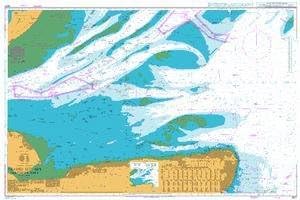
BA Chart 1607: England a East Coast, Thames Estuary, Southern Part
Numéro d'article:
124546048
XAF 85531
Price Details
Excluding Shipping & Custom charges ( Shipping and custom charges will be calculated on checkout )
*All items will import from États-Unis
0 ratings
Écrire un commentaire
En stock
QTY:
Commandez maintenant et recevez votre commande aux alentours du Vendredi, Juillet 03
Transaction sécurisée
Ubuy s'engage à protéger votre sécurité et votre confidentialité. Notre système avancé de sécurité des paiements garantit la confidentialité en chiffrant vos informations lors de la transmission grâce aux protocoles AES (Advanced Encryption Standards) et SSL (Secure Socket Layer). Vos coordonnées de paiement sont 100 % sécurisées car nous ne partageons pas vos informations de paiement avec des vendeurs tiers.
nos meilleurs partenaires logistiques
Admiralty standard nautical charts comply with Safety of Life at Sea (SOLAS) regulations and are ideal for professional, commercial and recreational use.
Livraison
rapide
Retour
gratuit*
Emballage sécurisé
Produits 100 % originaux
Conformité PCI DSS

Certifié ISO 27001
Note: Step Down Voltage Transformer required for using electronics products of États-Unis store (110-120). Recommended power converters Acheter maintenant.


Ce qui se démarque
Comprehensive Coverage
This nautical chart provides extensive coverage of the England East Coast and Thames Estuary, ensuring navigators have essential information for safe and effective navigation in these busy waters.
Detailed Information
With precise details on depths, hazards, and navigational aids, this chart enhances maritime safety, enabling sailors to make informed decisions and avoid potential dangers while navigating coastal waters.
Durable Material
Printed on high-quality, water-resistant material, this chart is designed for longevity and durability, ensuring it withstands the rigors of marine environments, providing reliable guidance for seafarers over time.
Détails du produit
| Item Weight | 1.5 lbs (680 grams) |
À qui est-ce destiné ?

-
Marine Navigators
Essential for navigators needing accurate maritime information for safe travels and navigation in the Thames Estuary.
-
Fishing Enthusiasts
Provides critical details about fishing zones and regulations, benefiting anglers looking to explore the area.
-
Shipping Companies
Valuable for shipping companies requiring reliable charts for transporting goods efficiently along the east coast.

-
Casual Boaters
Not ideal for casual boaters who may not require detailed navigation data for short leisure trips.
-
Land-based Travelers
Not suitable for those traveling overland, as the chart focuses solely on marine navigation and maritime routes.
-
Outdoor Recreational Crafters
May not meet the needs of outdoor crafters looking for comprehensive information on land trails or activities.
DESCRIPTION DU PRODUIT
BA Chart 1607: England a East Coast, Thames Estuary, Southern Part
Vous avez une question ? Chattez avec nous
Questions et réponses des clients
-
question:
What is included in the BA Chart 1607?
répondre: BA Chart 1607 includes detailed nautical information of the East Coast of England, particularly focusing on the Thames Estuary and its southern part. This chart provides crucial information such as depth contours, navigational aids, topographic features, and important landmarks. It ensures mariners have comprehensive guidelines for safe navigation, helping you identify hazards and navigate through congested waters effectively. Ideal for maritime professionals and enthusiasts alike, the chart also assists in planning routes and understanding tidal flows, ensuring informed decision-making on your journeys. -
question:
Who is the primary user of the BA Chart 1607?
répondre: The primary users of BA Chart 1607 are maritime professionals, including sailors, fishermen, and professional boat operators. Additionally, it serves as a valuable resource for sailing schools and maritime training centers. By providing crucial navigational data and topographic insights, it helps users navigate the complex waters of the Thames Estuary efficiently. Whether you're planning a local fishing trip or engaging in a large-scale maritime operation, this chart is essential for ensuring safe and effective navigation in these busy waters. -
question:
Is the BA Chart 1607 suitable for recreational boating?
répondre: Yes, BA Chart 1607 is highly suitable for recreational boating. It offers detailed information that aids in safe navigation along the East Coast, particularly for those cruising the Thames Estuary. Recreational boaters can benefit immensely from understanding water depths, tidal patterns, and potential hazards depicted on the chart. This ensures a more enjoyable and safe boating experience, whether you're sailing with family or friends, exploring coastal scenery, or engaging in water sports activities. -
question:
How does the BA Chart 1607 differ from other nautical charts?
répondre: BA Chart 1607 differs from other nautical charts by its specific focus on the Thames Estuary’s southern part, providing detailed local insights. Unlike broader maritime charts, this chart features meticulously plotted depths and navigational aids tailored for busy estuarine waters. The local detailing gives mariners a clearer understanding of this complex area, helping to avoid potential hazards. Moreover, it supports extensive marine activities such as fishing, yachting, and commercial shipping, making it a unique resource for navigating these waters. -
question:
What kind of updates are available for BA Chart 1607?
répondre: BA Chart 1607 is regularly updated to ensure it reflects the latest navigational information. Updates may include alterations in shipping lanes, modifications to buoy placements, changes in depth conditions, and newly reported hazards. Mariners can access these updates through the official BA website or related nautical publication platforms. Keeping your chart current is essential for maintaining safety and enhancing navigation accuracy, making it crucial for serious sailors and maritime operators to stay informed about these changes. -
question:
Can the BA Chart 1607 be used for commercial purposes?
répondre: Absolutely, BA Chart 1607 can be used for commercial purposes, making it a vital tool for shipping companies and freight operators. It provides precise navigational data necessary for commercial vessels navigating the busy waters of the Thames Estuary. The information aids in optimizing routes, ensuring that vessels can maneuver safely through crowded shipping lanes while adhering to maritime regulations. This makes the chart an essential resource for efficient and safe maritime operations in commercial shipping. -
question:
Are there digital versions available for BA Chart 1607?
répondre: Yes, there are digital versions available for BA Chart 1607, which can be utilized via navigation software or electronic charting systems. Digital charts offer enhanced features such as zooming capabilities, real-time updating, and easier integration with GPS systems, providing users with an engaging and interactive navigation experience. These digital formats are especially beneficial for tech-savvy mariners or those operating large fleets, enabling streamlined access to critical navigational data at their fingertips. -
question:
What are the benefits of using the BA Chart 1607 for sailing training?
répondre: Using BA Chart 1607 for sailing training offers numerous benefits, such as providing students with critical navigational skills in a practical setting. Instructors can utilize the chart to teach sailors how to interpret water depths, understand tidal influences, and identify local landmarks. The chart's detailed information equips trainees with the knowledge to make informed decisions during practice voyages, ensuring they are prepared for real-world sailing experiences. This grounding in practical navigation fosters confidence and skills that are invaluable in their future boating endeavors. -
question:
Is there a physical or hardcopy version of BA Chart 1607 available?
répondre: Yes, BA Chart 1607 is available in a physical format for those who prefer traditional charting methods. The hardcopy version offers durability and can be used in various maritime environments without the need for digital devices. This is particularly useful during outdoor activities where electronic systems might be less reliable. Mariners often carry both digital and physical charts to ensure they have all necessary resources for safe navigation, especially in coastal areas known for rapid changes. -
question:
Where can I buy BA Chart 1607: England – East Coast, Thames Estuary, Southern Part?
répondre: You can buy BA Chart 1607 at Ubuy, a trusted online marketplace known for a wide range of products including nautical charts. Ubuy provides a user-friendly shopping experience, ensuring that you can easily find, compare, and purchase this essential chart. With Ubuy, you are guaranteed access to a reliable source for all your nautical chart needs, making it a convenient option for maritime professionals and enthusiasts.
UKHO Charts & Maps Editorial Review
Aucune critique éditoriale trouvée
Avis et évaluations clients
1 évaluations des clients
-
5 étoile
100%
-
4 étoile
0%
-
3 étoile
0%
-
2 étoile
0%
-
1 étoile
0%
Donnez votre avis sur ce produit
Partagez votre avis avec d'autres clients
Historique des prix du produit
Informations importantes
- Limitations : Pour les produits expédiés à l'international, veuillez noter que toute garantie du fabricant peut ne pas être valide ; les options de service du fabricant peuvent ne pas être disponibles ; les manuels, instructions et avertissements de sécurité des produits peuvent ne pas être dans les langues du pays de destination ; les produits (et les matériaux qui les accompagnent) peuvent ne pas être conçus conformément aux normes, spécifications et exigences d'étiquetage du pays de destination ; et les produits peuvent ne pas être conformes à la tension et aux autres normes électriques du pays de destination (nécessitant l'utilisation d'un adaptateur ou d'un convertisseur le cas échéant). Il incombe au destinataire de s'assurer que le produit peut être importé légalement dans le pays de destination. En cas de commande auprès d'Ubuy ou de ses filiales, le destinataire est l'importateur officiel et doit se conformer à toutes les lois et réglementations du pays de destination.
- Tous les produits listés sur Ubuy ne sont pas à vendre, Ubuy étant un moteur de recherche mondial. Les produits sont soumis aux réglementations en matière d'exportation et de commerce.
XAF 85531
Commandez maintenant et recevez votre commande aux alentours du Vendredi, Juillet 03
This item is not restrict in my country.(Please click on above link if this item is not restrict in your country, So our team will review and allow.)
QTY:
Transaction sécurisée
Ubuy s'engage à protéger votre sécurité et votre confidentialité. Notre système avancé de sécurité des paiements garantit la confidentialité en chiffrant vos informations lors de la transmission grâce aux protocoles AES (Advanced Encryption Standards) et SSL (Secure Socket Layer). Vos coordonnées de paiement sont 100 % sécurisées car nous ne partageons pas vos informations de paiement avec des vendeurs tiers.
nos meilleurs partenaires logistiques
Livraison transfrontalière la plus rapide
Caractéristiques et avantages
- Compliant with SOLAS regulations for safety.
- Ideal for professional, commercial, and recreational navigation.
- Includes a range of scales for various nautical needs.
- Supplemented by mariners' routing guides in busy seaways.
- Corrected by trained cartographers with the latest notices.
- Produced by one of the leading nautical chart producers globally.